Google Maps, Waze and other navigation apps are powerful tools that can be used to determine road blockages and avoid traffic jams. Especially considering the current situation in Panama. Google Maps showing Road Blockages in real-time and other information about traffic conditions, including road closures, protests, and other disruptions, can greatly help to manage your trips and travels. By using Google Maps or Waze, you can plan your route accordingly and avoid surprises.
Steps on Using Google Maps showing Road Blockages
Here are the steps on how to use Google Maps to determine road blockages in Panama. The same logic applies to many other navigational apps. In short what usually needs to be activated is the traffic layer if not already activated.
- Open Google Maps app on your phone or computer.
- Zoom in on the area where you are interested in checking for road blockages.
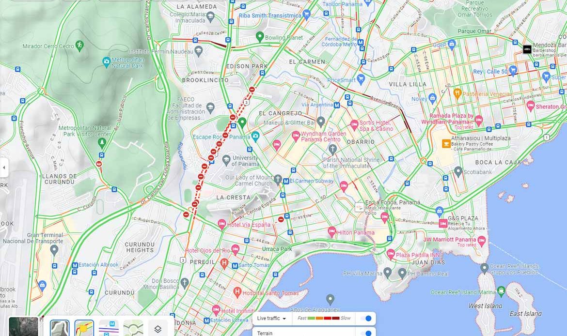
- Look for any areas of the map that are shaded red or orange. This indicates that there is heavy traffic or a road closure in that area.
- To learn more about a specific traffic incident, tap on the red or orange icon. This will open a pop-up window that provides more information about the incident, such as the type of incident, the severity of the impact, and the estimated time of clearance.
- To see where Panama protesters are blocking the road, you can use the Google Maps incident report feature. To do this, tap on the “Report a road closure” button at the bottom of the screen. Then, tap on the “Protesters” option and select the “Blocking the road” option. You can also provide additional information about the protest, such as the location, the number of protesters, and whether or not the protest is still ongoing.
Useful Tips
Here are some additional tips to use Google Maps showing Road Blockages in Panama:
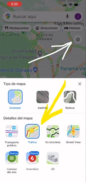
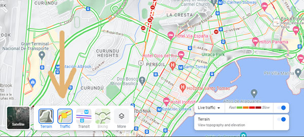
- Use the Google Maps traffic layer to see real-time traffic conditions. To do this, tap on the “Layers” button in the top right corner of the screen and select the “Traffic” layer.
- Use the Google Maps street view feature to see what the traffic conditions are like on a specific road segment. To do this, tap on the street view icon in the bottom left corner of the screen.
- Check the Google Maps traffic conditions before you leave for your destination. This will help you avoid any surprises and ensure that you arrive on time.
- If you see a traffic incident, report it to Google Maps so that other drivers can be alerted.
Examples for Using Google Maps
Here are some examples of how you can use Google Maps to determine road blockages in Panama:
- If you are planning to drive to downtown Panama City, you can use Google Maps to check for traffic conditions before you leave. If the traffic layer shows that there is heavy traffic or a road closure in the area, you can choose to take an alternate route.
- If you are aware of a protest that is taking place in Panama, you can use Google Maps to see where the protest is located and whether or not it is blocking the road. This information can help you avoid the protest area and find an alternate route.
- If you are driving on a highway in Panama and you see a road closure, you can use Google Maps to learn more about the closure and see how long it is expected to last. This information can help you decide whether to wait for the closure to be cleared or to take an alternate route.
The process for Waze
- Open Waze on your phone.
- Tap the Search button (magnifying glass icon).
- Type “protests Panama” in the search bar.
- Waze will show you a list of all the reported protests in Panama.
- Tap on a protest to see more information, including the location and the time it was reported.
- Also you can activate general road blocks like shown in the video below
Waze Alerts
Waze also has a feature called Alerts, which will notify you of any upcoming road blockages or other hazards along your route. To enable Alerts, go to Settings > Alerts and toggle on the Road closures and Alerts switches.
Report a Blockage –Help your Fellow Travelers
If you see a road blockage that is not listed in Waze, you can report it yourself by tapping the Report button (flag icon) and selecting Road closure.
Here are some additional tips for using Waze to see road blockages from protesters in Panama:
- Keep your Waze app up to date to ensure that you have the latest information.
- Zoom in on the map to see more detail about the road blockages.
- Use the Live Map view to see real-time traffic conditions.
Conclusion on Google Maps showing Road Blockages and other traffic conditions
By using Google Maps showing Road Blockages, you can avoid traffic jams and delays, and get to your destination on time. Especially considering the current mining crisis in Panama affecting many roads through its protests.
Waze is a community-driven app, so the accuracy of the information it provides can vary. It is important to use Waze in conjunction with other sources of information, such as local news and traffic reports or other apps like google maps. We’ve found it to be extremely accurate.